
Directions
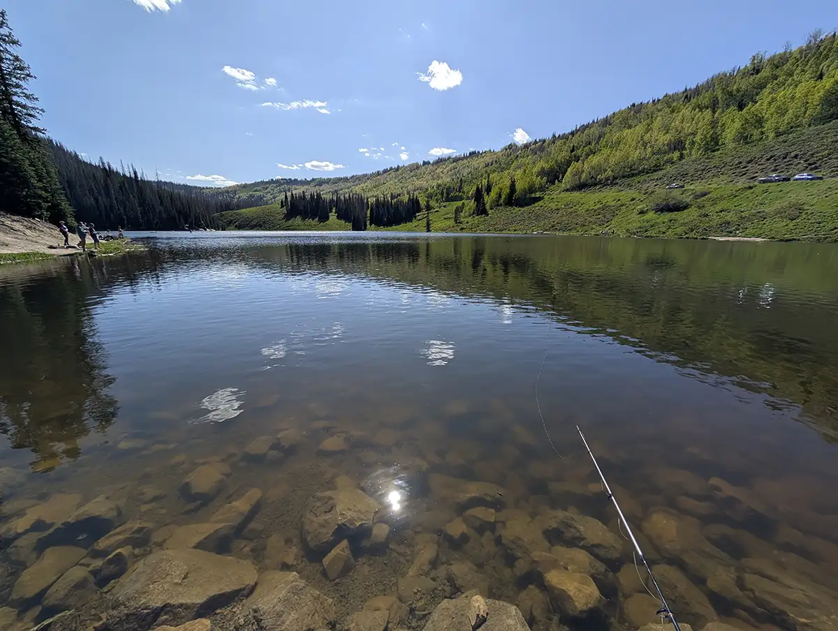
Mill Hollow Reservoir is located in Wasatch County, Utah. From Heber head North towards Jordanelle and turn East on State Road 32. This is the same turn for Kamas and Francis. Follow State Road 32 the road turns into E State Road 35. From Highway 40 in Heber to the turn into Mill Hollow Reservoir is about 25.5 miles. There is a sign for the turn to the reservoir. From road 35 you will take the dirt road 3 miles to the reservoir. This road is "typically" well maintained. Some years the road can be pretty washboard like. I've seen multiple low clearance cars make it to the reservoir. As long as it hasn't rained really hard recently you should be good on the dirt road in a car or SUV.
Fish Species
Rainbow Trout, Brook Trout, and Tiger Trout.
Campground Info
There are two options for camping in the area. Dispersed and paid campground.
The paid camp is at Mill Hollow Campground. This campground can be accessed by driving across the dam of the reservoir. This is a first come first served campground so you can't reserve it online. The site has drinking water, restrooms, picnic tables, and options for tents or trailers. Several of the reviews mention that they had a hard time fitting their trailer in the provided campsite, and that the document amount of space for a trailer may be greatly exaggerated. The camp site is a few hundred yards from the reservoir and is easily walk-able. The cost of a night stay is around $30. The site typically opens around the second week of June and closes in September. You can get more info on the 28 camping sites from Recreation.gov.
There is a bunch of dispersed camping areas near the reservoir. 1 mile below Mill Hollow Reservoir lies the guard station. Just east of the guard station there is two dirt roads. One of them is East Fork Mill Hollow which offers several places to camp. The other road is FR-122. This road offers lots of places to camp. This long winding road will eventually lead to heber.
History
Wasatch Wave 8/30/1912. Two people were killed in a saw mill explosion. The saw mill was running at 150 lbs. of pressure when it was found that the boiler was running short of water. Whereupon the engineer Mr. Wade took a bucket and poured cold water into the receptacle. The water of course immediately turned to steam and the explosion resulted. The boiler and the engine were thrown 180 feet up the hill. The owner of the mill, Mr. Charles Coullard was thrown 100 feet but escaped uninjured. Mr Wade and Mr Fuelling died in the explosion.
Duchesne Record 1/26/1916. Albert Smith made application to take water from two springs in the area and coming them into a ditch.
The Wasatch Wave 11/23/1934. The south Kamas Irrigation company filed an application to store 1,200 feet of water in the reservoir. The purpose of which would be used for irrigation. The fee was $800 and future construction of a dam would be estimated at $5,200.00. The undersigned asked for five years additional time to make final proof of the application.
The Daily Herald 10/21/1935. Edgar Mcarthur bagged a 250 pound buck on the opening of the mule deer hunt at Mill Hollow.
Salt Lake Tribune 06/07/1936 Applications sent to Washington by the WPA engineers to create seven small reservoirs. Including Manti National Forest, White Pine Lake Reservoir. Mill Hollow Reservoir in Wasatch County. Mill Site Dam in Emery County. Paradise Park Reservoir in Uintah County and Oaks Park reservoir in Uintah County.
The Daily Herald 7/22/1957. Wasatch Groups Plan to Build New Reservoir. The reservoir located approximately five miles above Camp Kill-Care, will be stocked with fish and offer excellent facilities in recreation. Plans are being completed through the combined efforts of the Civic Improvement Committee of Wasatch Chamber of Commerce, the Utah State Fish and Game Department, and the Uinta Forest Service. Work on the project will be started in the near future and is expected to be completed by early next year.
The Wasatch Wave 7/03/1958. A new road has been opened into the area by the Fish and Game Department. The Civic Improvement Committee requested additional funding from the federal government to create a reservoir.
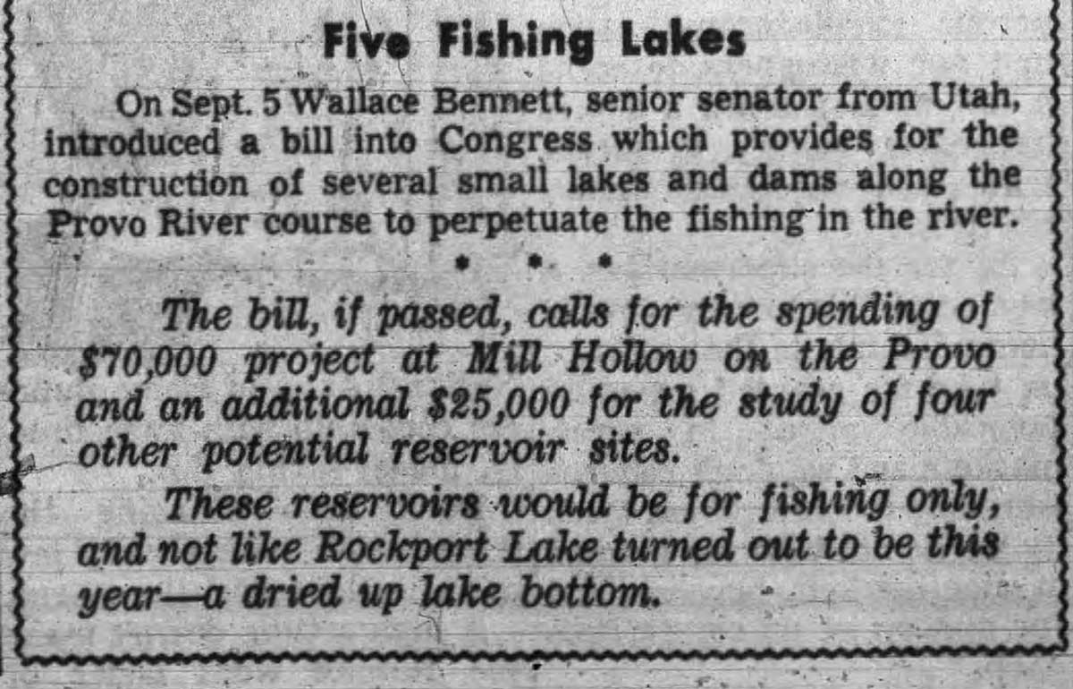
The Wasatch Wave 10/13/1960. When completed the dam will be 45 feet deep at its deepest spot and will cover approximately 19 acres. It will be open round with a cement spillway. Cost of the project is estimated between $20,000 and $25,000.
The Wasatch Wave 10/18/1962. The dam is being constructed by E.V Chettle of Salt Lake City at a cost of approximately $45,000. Designed for a constant level lake, the State Engineers are installing weirs above and below the reservoir to measure any loss due to evaporation. Mill Hollow Creek runs about 3 second feet and is a tributary to the South Fork of the Provo River. Forest Service is clearing grounds to handle 28 family unit campgrounds.
Deseret News 8/07/1963. The dedication of Mill Hollow Reservoir will take place on August 13th 1963 at 9:30 am. Work on the 45 foot dam was initiated in June of 1962, with construction reaching completion last October. Built at a cost of $63,000 the reservoir together with adjoining Forest Service camp grounds has been open since the beginning of the 1963 angling season. The water has been heavily stocked with catchable sized rainbow trout and fingerling brook trout.
Nearby Areas to Fish
Heart Lake(no fish) , Jordanelle Reservoir, Timber Lakes, Wasatch Mountain State Park Pond.