
Places to fish in the Weber River Drainage, and the fish stocked there.
Abes W-30: Cutthroat 2006, 2010. Tiger Trout 2011, 2015.
Adax W-34: Not stocked. Naturally reproducing Brook Trout.
Anchor W-29: Not stocked. Naturally reproducing Brook Trout.
Arrowhead W-68: Not stocked. Naturally reproducing Brook Trout.
Bench W-37: No longer stocked due to winter kill. Fish doubtful.
Carol W-51: Stocked every even year with Brook Trout
Castle W-67: Not stocked. Naturally reproducing Cutthroat.
Cuberant #1 W42: Brook Trout 2006, 2009, 2012, 2015.
Cuberant #2 W-43: Not stocked natural Cutthroat and Brook.
Cuberant #3 W-44: Brook Trout 4 year cycle, 2014, 2018.
Cuberant #4 W-45: Cutthroat 2006, 2010. Tiger 2011, 2014, 2016.
Cuberant #5 W-46: Winterkills, no longer stocked.
Dean W-35: Brook Trout 2007, 2012, 2015. Grayling 2013.
Divide #2 W-20: Winterkills, no longer stocked.
Elkhorn W-64: Brook Trout 2008, 2012, 2014, 2017.
Erickson South W-25: Brook Trout 2012, 2013, 2017.
Erickson North W-26: Brook Trout 2008, 2010, 2015.
Fish W-47: Grayling. Also heard rumors of Brook and Cutt.
Fran W-39: Not stocked, natural Brook Trout.
Ibantik W-24: Naturally reproducing Brook Trout.
Jean W-58: Golden Trout 2014, 2015. Cutthroat 2006, 2004.
Jerry W-28: Brook Trout 2012, 2014, 2016, 2018.
Kamas W-40: Tiger 2011. Cutthroat 2006, 2010, 2015.
Little Hidden W-21: Brook Trout 2008, 2014, 2017.
Lofty W-41: Tiger Trout 2011. Cutthroat 2010, 2015.
Lovenia W-23: Brook Trout 2008, 2012, 2015.
Meadow W-27: Tiger Trout 2014. Naturally reproducing Cutthroat.
Neil W-31: Brook Trout 2006, 2010, 2014.
Notch, W-36: Brook Trout 2010, 2012, 2014, 2016, 2018.
Olsen W-32: Brook Trout 2012, 2015, 2018.
Reids W-38: Brook Trout 2013, 2014,2016, 2017.
Rhoads W-33: Naturally reproducing Brook Trout.
Round W-48: Arctic Grayling and Cutthroat Trout.
Sand W-49: Arctic Grayling.
Shingle Mill Lake W-69: Wouldn't sustain Brook, no longer stocked.
W-5: Doesn't sustain fish.
W-14: Doesn't sustain fish.
W-15: Doesn't sustain fish.
W-16: Brook Trout 2009, 2012, 2015, 2018.
W-17: Doesn't sustain fish.
W-18: No fish, but does have Tiger Salamanders.
W-52: Brook Trout, 2008, 2012, 2016. GMaps lists as Salt Fish Lake.
W-53: Brook Trout stocked every even year.
W-54: Doesn't sustain fish.
W-56: Doesn't sustain fish.
W-57: Brook Trout 2010, 2013, 2016.
W-59: Naturally reproducing Brook Trout. GMaps incorrectly labeled.
W-60: Doesn't sustain fish.
W-61: Doesn't sustain fish.
W-62: Brook Trout 2010, 2013, 2016.
Yellowpine Lower W-66: Stocked yearly with Brook Trout.
Yellowpine Upper W-65: Stocked every even year with Brook Trout.
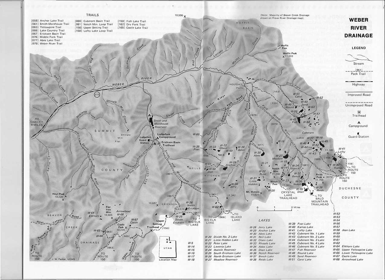
The map below is the GPS marked coordinates to the Weber River Drainage. Click on each map marker to reveal the name of the lake, or click on the x to conceal the name.
These are the drainage's that make up the Uinta Mountains. Click on any of them to find out more. Ashley Creek Drainage, Bear River Drainage, Beaver Creek Drainage, Blacks Fork Drainage, Burnt Fork River, Carter Creek Drainage, Dry Fork Drainage, Dry Gulch Drainage, Duchesne River Drainage, Henry's Fork Drainage, Lake Fork Drainage, Provo River Drainage, Rock Creek Drainage, Sheep Creek Drainage, Smith Fork Drainage, Swift Creek Drainage, Weber River Drainage, Whiterocks River Drainage, and Yellowstone Drainage.