
Directions
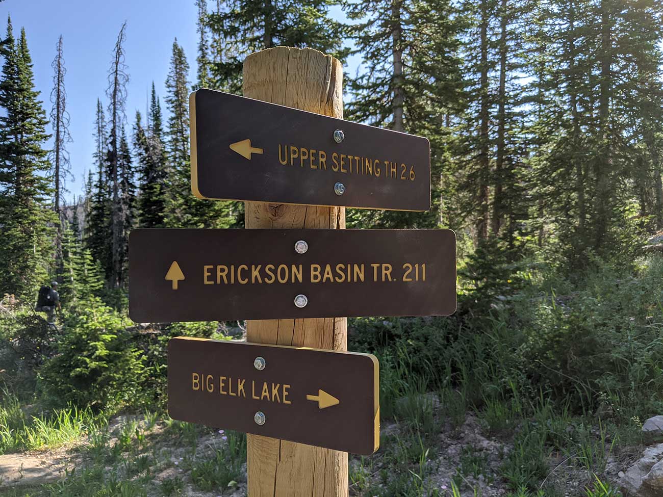
North Erickson Lake W-26 is located in Summit County, Utah. The lake is part of the Uinta-Wasatch-Cache National Forest and lies in the Weber River Drainage of the High Uintas. There are three hikes you can take to access the lake. I recommend the Upper Setting trail.
Upper Setting Trail. 5 miles.
The Upper Setting Trail is the easiest hike to the lake. From Mirror Lake Highway take the Upper Setting Road for 6.7 miles until the road end. The road can get a bit rough the last mile or two and a medium clearance vehicle is recommended. The Upper Setting Trailhead starts at the end of the road. The hike is 2.5 miles each way, 5 miles round trip and has a 690 ft elevation gain. The first 1.6 miles to East Shingle Creek Lake is a really mellow hike. Once you get past East Shingle Creek the elevation changes quickly. I had to stop for a rest many times in that area. Although the trail was easy to follow. The trail will lead to South Erickson, then you will have to drop down a 1/4 mile north. I couldn't find a trail in the area but you can sort of follow the sand stone rocks down until it appears. Also the stream flows into the lake so I you see the stream just follow that.
North Erickson Lake Trail, Erickson Basin Trail, and Smith and Morehouse Lake Trail. 10 miles.
This hike goes by a few different names but has the same trailhead and trail. On the south end of Smith and Morehouse Lake the trailhead starts near LedgeFork Campground. Of the three routes this is the best one for a lower clearance vehicle. The trail is about 5 miles each way and 10 miles round trip. A GPS is recommended for this hike. There are some cairns (rocks stacked) along the way you can use for navigation. The basic route follows Smith and Morehouse Creek and then Erickson Creek. The Elevation gain is 2,384 feet and most of it happens the last two miles.
Big Elk Lake via Norway Flats. 7 miles of hell.
This terrible road has sharp slate rocks which often pop tires. The hike is pretty much as horrible as the drive up. You should not go this route. You will need a high clearance vehicle with spare tires. From Mirror Lake Highway take the turn to Norway Flats. Follow Forest Road 035 for 5.4 Miles and turn onto Forest Road 916 and park at the pond a few hundred yard up. It is possible to keep going up Forest Road 035 past this spot, but you're stupid if you do. If you're stupid and keep driving up DO NOT TAKE FR 035B, stay on 035A.
From the Pond at Forest Road 916, hike up the hill to Little Elk Lake, then follow FR 035 up to Big Elk Lake. This distance is 2.5 miles. From Big Elk Lake the trail is pretty hard to find. You will go 300 feet in elevation in .3 miles. We got lost a whole bunch of times and easily turned this into a mile and a half. In 2020 when I last did this hike there were some cairns (stacked rocks) marking the best route. I highly suggest you follow these. You will pass a couple of salamander ponds. It look like you're almost over the pass several times then you get over a hill and see several more. According to the map it is only 1 mile from Big Elk Lake to South Erickson Lake. Then you can drop down a 1/4 mile to reach North Erickson Lake.
Fish Species.
Several years back there was a blog article about big brook trout being caught here. This article spread and a reputation quickly grew. People started flocking to this small lake in order to catch a famed large brook trout. Other websites repeated the information blindly, and the lake became more popular. The truth is your chances of catching a trophy fish here are very unlikely.
The average brook trout life span in the Uintas is 3 years. For a brook trout to exceed the 16" size mark it will have to live for more than 3 years. This is more likely in deep Uinta mountain lakes, but not in a 12 foot deep lake prone to winter kill. Brook Trout are stocked on average in the lake every 3 years. The most likely catch here will be under 12". If you want to catch something larger, go to Big Elk Lake.
Other Info
The Erickson Basin, creek and lakes are named after a lumberjack from the early 1900's.
Historical DWR Info
1964
ERICKSON NO. 2, X-7. Also known as Waterdog. 18 acres, elevation 9,500 feet, maximum depth 14 feet, average depth 6.2 feet. Excellent fishing for Eastern brook to 14 1/2 inches from late June to August. Horse feed and good campsites. 5 miles on poor trail from Trial Lake to Big Elk, then over ridge past Erickson No. 1, 1/4 mile. Lake is stocked with brook trout. Record of winter kill. Some open areas on these two lakes for fly fishing.
1999
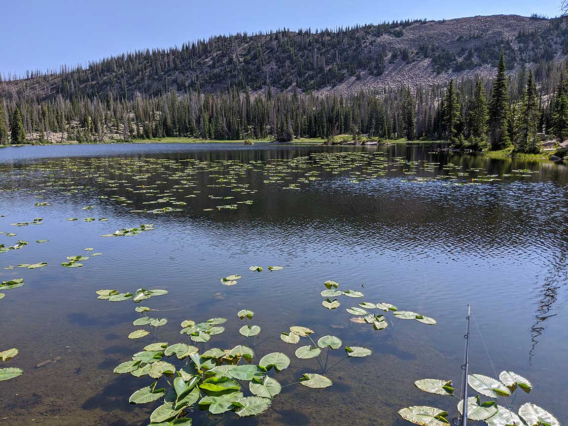
ERICKSON, NORTH, W-26. North Erickson is a spring-fed lake located in a meadow within Erickson Basin. It is 9 acres, 10,020 feet in elevation, with 12 feet maximum depth. Several camping areas are present with good supplies of spring water. Limited horse feed is available from the surrounding meadow. Access begins at the end of the Upper Setting Road on the Upper Setting and Erickson Basin trails to South Erickson and then proceed north for 1/4 mile to North Erickson. The lake is shallow and has a history of winterkill. However, North Erickson receives frequent stocking of brook trout and sustains heavy fishing pressure.
Nearby Places to Fish
South Erickson Lake W-25, is a 1/4 mile north uphill and the trail is non existent. Look towards the pass between the mountain to the north and follow the smooth sand stone up.
Big Elk Lake A-18 is 1 1/4 mile hike if you can get it right the first time. Follow the Sand stone up and veer east of South Erickson. The pass is very steep but not too hard to climb. Follow the cairns (rock stacks). Once you come over the pass you will see 3 lakes. The top lakes don't have fish but do have some salamanders. It looks like you can go to the west of the top two ponds for a short cut to Big Elk lake but this is a very bad idea. Instead stay to the east of the two salamander ponds. The hike down is horrible try and look for the cairns whenever possible since there is no trail. Keep aiming east of Big Elk in order to avoid the 20 foot cliffs. If you can find the correct route the hike isn't is bad, although I got lost several times.
Following the Upper Setting Trail to the west you can access East Shingle Creek A-39, Lower Shingle Creek P-62, and West Shingle Creek P-60. Other nearby fisheries include. Castle Lake W-51, Little Elk A-19, Hourglass Lake A-48, Beaver Lake A17, Duck Lake A-7, Fire Lake A-14, Island Lake A-57, Ramona Lake A-38, Weir Lake A-50, and Majorie Lake A-12.